
...but will the public have easy access to the data?
Something this article does not address. India's remote sensing program is no doubt a great science and technology success and the imagery and digital data is being used by scientists for research and natural resource management.
Where India and ISRO are falling short is the continued denial of the best quality images to the public at large. Bhuvan - ISRO's answer to Google Maps - launched a few years ago is still serving images of India which are frustratingly inadequate for users who have by now become accustomed to razor sharp quality images of their cities and countryside from Google Maps and Google Earth.
The remote sensing satellite Cartosat-2 series has been imaging India using a panchromatic sensor at a 0.8 meter resolution since 2007. In July 2011 India announced a new Remote Sensing data policy which allowed distribution of 1 meter resolution imagery without additional security checks. The previous policy did not allow unrestricted access to imagery finer than 5.8 meters. The policy change should ideally have resulted in image streaming applications like Bhuvan to present much sharper images of India. Almost two years since we are still getting a grainy view of India from Bhuvan. Is the new policy not extendable to open access image streaming applications? If so, why not? Pointing to reasons of national security does not make sense since fine resolution imagery is already available through applications like Google Maps to users in India.
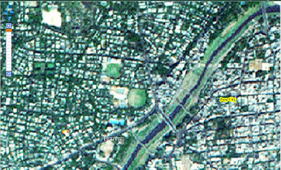
The image below of a portion of Pune city is the best resolution available via Bhuvan and it means that tens of millions of potential users will stay away and use Google instead.
Something this article does not address. India's remote sensing program is no doubt a great science and technology success and the imagery and digital data is being used by scientists for research and natural resource management.
Where India and ISRO are falling short is the continued denial of the best quality images to the public at large. Bhuvan - ISRO's answer to Google Maps - launched a few years ago is still serving images of India which are frustratingly inadequate for users who have by now become accustomed to razor sharp quality images of their cities and countryside from Google Maps and Google Earth.
The remote sensing satellite Cartosat-2 series has been imaging India using a panchromatic sensor at a 0.8 meter resolution since 2007. In July 2011 India announced a new Remote Sensing data policy which allowed distribution of 1 meter resolution imagery without additional security checks. The previous policy did not allow unrestricted access to imagery finer than 5.8 meters. The policy change should ideally have resulted in image streaming applications like Bhuvan to present much sharper images of India. Almost two years since we are still getting a grainy view of India from Bhuvan. Is the new policy not extendable to open access image streaming applications? If so, why not? Pointing to reasons of national security does not make sense since fine resolution imagery is already available through applications like Google Maps to users in India.
The image below of a portion of Pune city is the best resolution available via Bhuvan and it means that tens of millions of potential users will stay away and use Google instead.

No comments:
Post a Comment