
I've written before ( 1 2 3) on hydrogeologically complex aquifers of Deccan Basalts and other hard rock terrains in India and how they influence farmer livelihoods by controlling access to groundwater.
Mysaiah et al have published a paper (open access) in Current Science on the use of ground penetrating radar in imaging subsurface fracture systems (sheet joints) in granitic terrains around the city of Hyderabad.They suggest in their paper that this sort of information will be useful for modeling and understanding groundwater flow in shallow aquifers as well as a host of other engineering applications.
Here is an example of the imaged sheet joints:
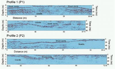 Source: Mysaiah et al 2011
I wonder if this technique can be adapted by state groundwater agencies to survey large tracts of land when mapping aquifer potential in other hard rock terrains like Deccan Basalts. This volcanic terrain too has a rock structure interrupted by horizontal sheet joints which control storage and flow of groundwater. The image below of a dug well shows ground water flowing out of the sheet joint in basalts.
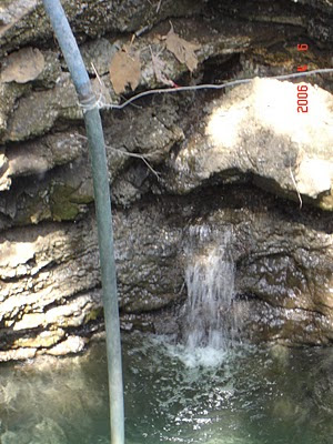
Source: ACWADAM
State agencies when compiling working plans usually use the local watershed as the hydrologic unit when delineating aquifers. This in the end translates into a sort of generalized advice on groundwater potential and management to farmers. This is often of little use to especially small land owners who are farming plots less than a couple of acres or so. This scale of mapping will say nothing about what lies beneath such small plots.
Yet it is these small land owners who are in the most need of very specific advice on groundwater potential. In large regions of the Deccan Basalts and also in the granitic terrains of south India, monsoons and groundwater are the only source of water.
Farmers livelihoods depends on the aquifer properties. For making informed decisions on investing on drilling or digging for water, farmers would like to know whether fracture systems that could potentially yield water underlie their fields or whether they are sitting on top of a likely unyielding basalt or granite monolith. These are the types of investments which if they fail result in the farmer going down a path of indebtedness from which it is not easy for them to recover.
At a community level too there are movements now in India for farmers to form village level water sharing cooperatives and such surveys may lead to better ground water management practices.
Land based radar surveys of large areas may be cumbersome and expensive.. but it is an investment in technology and basic data generation that the government should give serious thought to - for it will result in a detailed and more site specific understanding of the shallow ground water system on which millions of farmers in India rely upon.
Mysaiah et al have published a paper (open access) in Current Science on the use of ground penetrating radar in imaging subsurface fracture systems (sheet joints) in granitic terrains around the city of Hyderabad.They suggest in their paper that this sort of information will be useful for modeling and understanding groundwater flow in shallow aquifers as well as a host of other engineering applications.
Here is an example of the imaged sheet joints:

I wonder if this technique can be adapted by state groundwater agencies to survey large tracts of land when mapping aquifer potential in other hard rock terrains like Deccan Basalts. This volcanic terrain too has a rock structure interrupted by horizontal sheet joints which control storage and flow of groundwater. The image below of a dug well shows ground water flowing out of the sheet joint in basalts.

Source: ACWADAM
State agencies when compiling working plans usually use the local watershed as the hydrologic unit when delineating aquifers. This in the end translates into a sort of generalized advice on groundwater potential and management to farmers. This is often of little use to especially small land owners who are farming plots less than a couple of acres or so. This scale of mapping will say nothing about what lies beneath such small plots.
Yet it is these small land owners who are in the most need of very specific advice on groundwater potential. In large regions of the Deccan Basalts and also in the granitic terrains of south India, monsoons and groundwater are the only source of water.
Farmers livelihoods depends on the aquifer properties. For making informed decisions on investing on drilling or digging for water, farmers would like to know whether fracture systems that could potentially yield water underlie their fields or whether they are sitting on top of a likely unyielding basalt or granite monolith. These are the types of investments which if they fail result in the farmer going down a path of indebtedness from which it is not easy for them to recover.
At a community level too there are movements now in India for farmers to form village level water sharing cooperatives and such surveys may lead to better ground water management practices.
Land based radar surveys of large areas may be cumbersome and expensive.. but it is an investment in technology and basic data generation that the government should give serious thought to - for it will result in a detailed and more site specific understanding of the shallow ground water system on which millions of farmers in India rely upon.
No comments:
Post a Comment